iPhone · iPad · iOS 18.4+
Trip Compass Ride
Your speed, the road's posted limit, your direction of travel and the name of the street you're on — plus how far the ride has gone, how steep it is and how much it has climbed. Sized to be read with a glance from the handlebars or the driver's seat, in a dark face for night and a light one for daylight, and nothing else on the screen.
Request a beta invite Privacy policy
Private beta on TestFlight — invites by request. Needs iOS 18.4 or later.
What's on the screen
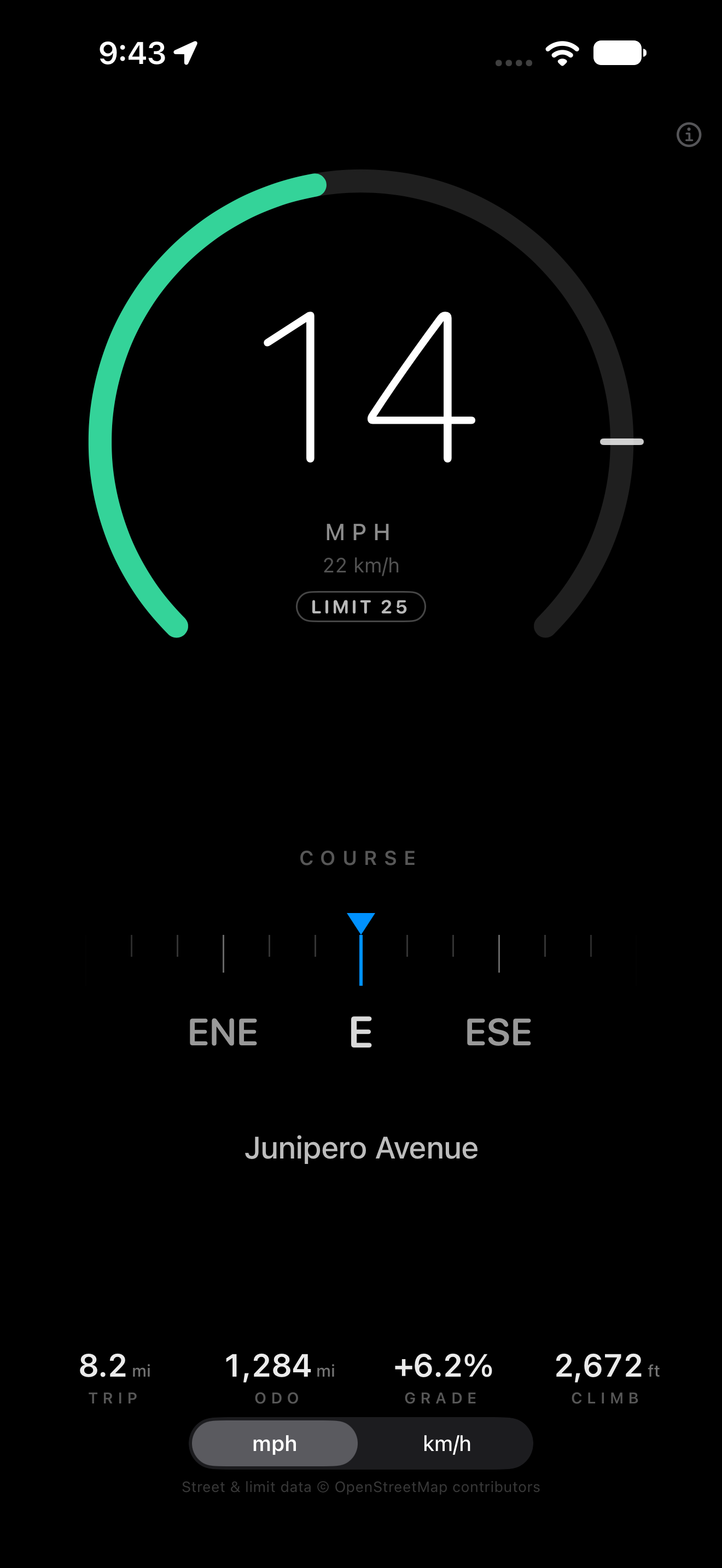
One dashboard, split between a speed gauge and a direction panel. Upright they stack; turned sideways in a mount they sit side by side. Nothing moves unless you do.
- Speed
- The current speed as a whole number, in mph or km/h — the picker remembers your choice between launches, and the other unit sits underneath in smaller type.
- The arc
-
A ring that fills with your speed, coloured against the road's posted
limit, with a tick where the limit falls and a
LIMIT 30badge repeating the number. On a road with no mapped limit the badge readsLIMIT NOT AVAILABLErather than disappearing. - Direction
- A fixed-marker heading tape: 90° of compass slide past a centre marker, labelled every 22.5°. The distance a mark travels is the size of the turn. It is damped, so the ribbon glides instead of jumping between readings.
- Street
- The name of the road you're on, when the app can get one — and off in one switch if you'd rather not see it.
What the colours mean
| Band | Meaning |
|---|---|
| Green | At or under the posted limit |
| Amber | Over the limit, up to your warning band — 5 mph unless you change it |
| Red | Beyond the warning band |
The warning band is yours: 0 to 15 mph in 1 mph steps, or 0 to 24 in whole km/h on the km/h dashboard, and it moves the amber and red edges together while green stays on the post. At zero the arc turns red the moment you pass the limit. The colours are keyed to the sign, never to the size of the dial.
On a road with no known limit the arc isn't drawn at all. Green there
would claim the app knows the posted speed when it doesn't — and the
badge says LIMIT NOT AVAILABLE rather than going blank, so
you can tell "no limit mapped" from "no data yet".
Two sensors, and it says which
While you're moving, direction comes from GPS course over ground and the
label reads COURSE — the direction you are actually
travelling. Stopped, or with no course available, it switches to the
magnetometer and reads HEADING, so a parked phone points where
it faces rather than where it last went. The compass follows the device
orientation, which is what makes it read correctly when the phone is
clamped sideways.
The ride, in four numbers
Under the dials, a strip that no gauge can give you: how far this ride has gone, how far the phone has ever gone, how steep the road is right now, and how much the ride has climbed. It is one row of text, read at a junction rather than at a glance, so it stays out of the way of the two instruments that matter while you are moving.
- Trip
- Distance ridden since the last reset, measured between accepted GPS fixes — and deliberately not counting the metre or two a parked phone drifts, the gap left when the app was in the background, or a bad fix that jumps across town.
- Odometer
- Every metre this phone has ridden, kept across launches and across trip resets, because it is the number you read to know how far the bike has gone this year. Zeroing it asks first.
- Grade
- The gradient you are on, signed, to a tenth of a percent, measured over the last 40 metres of travel — so it settles instead of flickering with every fix. It comes from the phone's barometer, which resolves a centimetre; GPS altitude resolves tens of metres, which is the difference between a readable 6.2% and a wandering 17%.
- Climb
- Elevation gained this ride. A descent lowers the baseline without taking the climb back, so a there-and-back ride climbs once, not twice and not zero.
Distance and climb follow the unit the dashboard is already in: miles and
feet on the mph face, kilometres and metres on the km/h one. A gradient the
app has not measured yet reads as a dash — a flat road and an unmeasured
one are different facts, and a 0.0% that means "unknown" would
be a lie. On hardware without a barometer (an iPad), grade and climb fall
back to GPS altitude with wider noise thresholds, and Settings says which
source is in use.
Making it yours
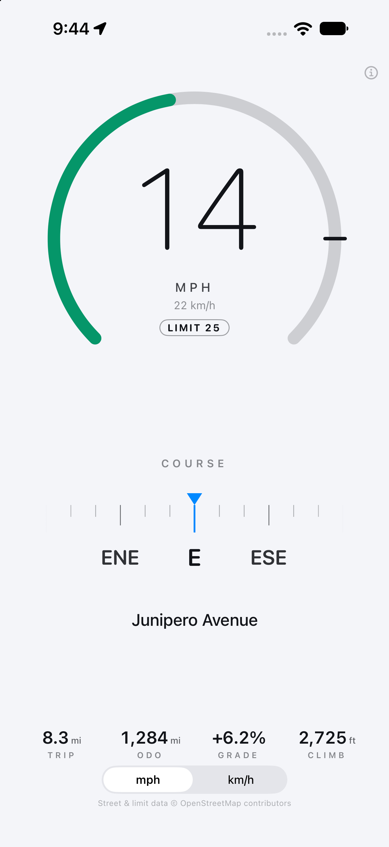
Everything adjustable lives behind the small information button in the corner: how the dashboard looks, how much colour the limit earns, how much speed the dial spans, and the ride's two resets. Every choice is remembered.
- Four faces
- Dark is white on black, so it doesn't light the cabin at night. Light is ink on paper for daylight. System follows the phone's own Appearance setting. Auto ignores that setting and switches on the sun — dark after sunset, light after sunrise, from where you are, changing while you drive rather than at the next launch.
- Night vision
- Draws the whole dashboard in red after dark, which leaves your night vision intact on an unlit road. The amber and red bands become three brightnesses of red, so the over-limit warning still reads at a glance.
- What you're on
- Car or Bicycle. A bicycle dashboard opens on a 30 mph arc and dims — holding the reading at zero — after three seconds of stillness, then wakes within a second of moving again. The compass stays live and readable while it is dimmed.
- The arc's maximum
- 60, 80, 90 or 120 mph in a car; 20, 30, 45 or 60 on a bike. A ring has only so much circumference: 30 mph fills a third of a 90 gauge and half of a 60 one, so a shorter maximum puts the limit tick and the colours where you can actually read them. If a road's limit is above the maximum you picked, Settings says so instead of quietly pinning the tick to the end of the arc.
- Street name
- On or off, without touching the road lookup — the limit and its colours stay.
- Ride resets
- Reset ride clears the trip and the climb; Reset odometer clears everything and asks before it does.
- Road data
- The OpenStreetMap lookup is off until you turn it on here. That switch is the only thing that ever sends your location anywhere.
What it needs, and what it won't do
Street names and speed limits come from OpenStreetMap
iOS has no speed-limit API — not MapKit, not Core Location — so the street
name and the posted limit are read from the maxspeed tag on
OpenStreetMap, through its Nominatim reverse geocoder. Road
lookups are off until you turn them on, in Settings (the
information button in the corner). With them on, an approximate location (rounded to
about a metre) goes to Nominatim; speed, compass, distance and elevation
readings never leave the device. Turning the setting off clears the road
data and cancels any lookup in flight.
Lookups are throttled well inside Nominatim's one-per-second policy: at most one every three seconds, only after moving 50 m, cached for five minutes within a car's length, with a one-minute backoff after a failure. Street and limit data is © OpenStreetMap contributors, under the ODbL.
What it is not
- Not a substitute for your speedometer, and not a satnav. There is no map, no route, no turn-by-turn.
- No offline road data. Without a connection, speed, direction and the ride numbers still work; street name and posted limit don't.
- Not every road has a posted limit in OpenStreetMap — most residential streets don't, and the arc stays empty there.
- Grade is a gradient, not a map: it knows how steep the ground under you is, not how steep the next mile will be.
- It keeps the screen awake while it's open, because a dashboard that dims is a dashboard you can't read.
The beta
1.0 passed Apple's beta review on 31 October 2026. 1.1 — the four faces, the adjustable warning band, the arc's new maximum and bicycle mode — went to Apple on 2 November. 1.2 adds the ride strip: trip, odometer, grade and climb, with the gradient read from the barometer. The beta is small and invitation-only: ask me and I'll add your Apple ID, and TestFlight emails you the build. There's no public link, and no App Store release yet — the app is Trip Compass Ride on the store and Trip Compass under the icon.
Request an invite — the draft asks for the three things I actually need: your Apple ID email, your device and iOS version, and whether it's going on a bike or a dash.
Testers are asked to mount the phone and ride: confirm the speed tracks the
speedometer, that the arc changes colour at the sign's number, that the tape
follows a turn without spinning at north, and that the reading switches from
COURSE to HEADING when you stop. New in 1.2:
ride a hill and watch grade settle on a percentage, check
that climb only goes up, and see whether
trip stays put when the bike is parked outside a café.
Feedback by email
is the fastest route — it reaches me, not a ticket queue.
Privacy, in one line
No account, no analytics, no advertising, no server of mine. The only thing that ever leaves the phone is the road lookup you switch on, and that goes to OpenStreetMap. Read the full policy.
Get in touch
Beta invites, bug reports, or a feature you actually want while riding: